The Department of Emergency Management presented the Sonoma County Board of Supervisors with a workshop on the threat of earthquakes at Wednesday’s board meeting as part of our ongoing, quarterly series of threat assessments.
The series started in January with a workshop on flooding, which prepared us well to respond effectively to the deluge of rainfall we received this year, and will be followed later this year with workshops on wildfires and cyber-attacks.
We all realize that we live in an area with seismic activity. We had a 4.1 just a few days ago in the Geysers near Cloverdale, and those of us in north county occasionally feel the slight 3.0s that rumble out of that area on a weekly basis.
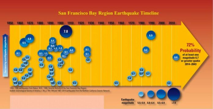
Strikingly, we received the sober news that the United States Geological Survey (USGS) estimates that the San Francisco Bay Region has a 72 percent probability of one or more magnitude 6.7 earthquake(s) in between now and 2043.
For context, the Loma Prieta quake of 1989 reached a 6.9 on the Richter scale. If we dive deeper into Sonoma County, we have both the San Andreas Fault on our coast and the Rodgers Creek Fault running straight through the gut of Sonoma County through Santa Rosa, Mark West/Larkfield and up almost to Geyserville in the north.
Its southern limit connects with the Hayward Fault which extends south through the East Bay. Tim Dawson, senior engineering geologist with the USGS, who presented to the board this week called the Rodgers Creek Fault Sonoma County’s “most dangerous fault,” due to its proximity to population centers and its projected 33 percent chance of a 6.7 magnitude or greater earthquake in the next 30 years.
Since the Rodgers Creek and Hayward faults were discovered to be connected in 2015, the risk to Sonoma County is increased, with an estimated maximum magnitude 7.4 earthquake that could cause massive damage to the area.
Department of Emergency Management Director Chris Godley presented the scenario of a 7.2 hitting the area and estimated that, depending on the time of day, we could see dozens of deaths, the loss of more than 10,000 single family homes and another 10,000 multi-family residential units, as well as thousands more structural losses in commercial buildings.
Residents could expect to be without power and water for days or weeks, and that the area would suffer from huge impacts in the form of other failed infrastructure such as the many bridges we use to connect our communities.
In the hours after the initial earthquake, which could last up to three minutes in terms of earth shaking, aftershocks would then be expected to further weaken structures, water treatment systems and other critical infrastructure.
One of the biggest impacts is that an earthquake of that magnitude and with an epicenter in the San Pablo Bay would have far-reaching effects on the entire Bay Area, all the way down to San Jose, meaning that assistance from outside the area would be stretched extremely thin.
All of these dark prophecies point us again to the bottom line: every one of us must be ready for disaster. Be prepared!
Some things you can do right now:
Take any heavy framed pictures off the wall that are hanging over beds in your home, and use tethers and wall mounts for heavy furniture like wardrobes, or chests of drawers.
Read this for more information.
Forays into the Fourth District is written this month by Fourth District Supervisor James Gore.
54.2
F
Healdsburg
July 18, 2025


